100 Mile Wilderness Trip Report: 6 Days of Remote, Rugged Hiking Through Northern Maine Along the Appalachian Trail
by Hartley Brody
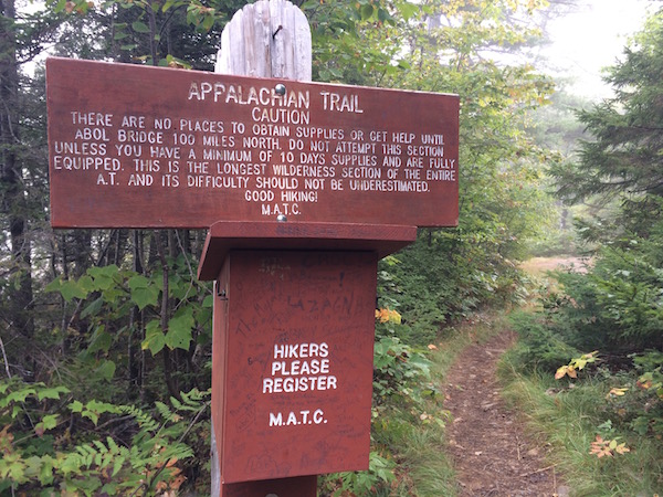
I just got back from completing the 100 Mile Wilderness, an epic, bucket list backpacking trip with some of the most remote, rugged hiking I’ve ever done.
We had planned to complete the 100 mile journey northbound from Monson, Maine to Abol Bridge in 7 days, but we ended up completing it in only 6. While the trail doesn’t cross any paved roads in its entire length, we were able to schedule a resupply van to come meet us on day 4.
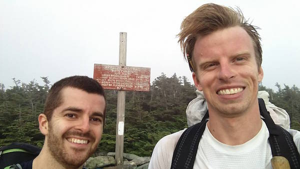
I completed the hike with Nick – a hardy, life-long Mainer and friend I met in my Wilderness First Responder class back in January. He and I had done some hiking in The White Mountains of New Hampshire since the WFR class, and he is well on his way to completing the 48 4000-footers in New Hampshire. As I found out on the drive up, this was his first real backcountry backpacking trip.
Like all good adventure tales, this one has multiple acts:
- Act I was the first 3 and a half days, mostly defined by rain and slow miles over lots of elevation
- Act II was the remainder of the trip, defined by sunny skies, lake-side hiking and lots of fast miles
To break up this 8500 word story – a lot happened over the course of 100 miles! – I’ve included some links directly to each of the days’ sections:
- Day 0: Boston to Shaw’s Hiker Hostel
- Day 1: Route 15 to Long Pond Stream (15.1 miles)
- Day 2: Long Pond Stream to Chairback Gap (10.9 miles)
- Day 3: Chairback Gap to Logan Brook (17.1 miles)
- Day 4: Logan Brook to Antlers (19.6 miles)
- Day 5: Antlers to Crescent Pond (17.9 miles)
- Day 6: Crescent Pond to Abol Bridge (18.8 miles)
- Day 7: Getting Home
I’ll post a “lessons learned” and “tips for planning your 100 Mile Wilderness hike” article separately.
Day 0: Boston to Shaw's Hiker Hostel
On Friday, September 16th, I took the train into Portland from Boston’s North Station. I got some funny looks carrying a loaded 45L backpack, hiking poles and a shopping bag with 10lbs of food through busy transportation centers.
One man told me it looked like I was hiking across the country. While on the train, the couple sitting across the aisle chatted with me for awhile, asking about the trip. Another woman a few rows back overheard our conversation and wished me good luck when she got off.
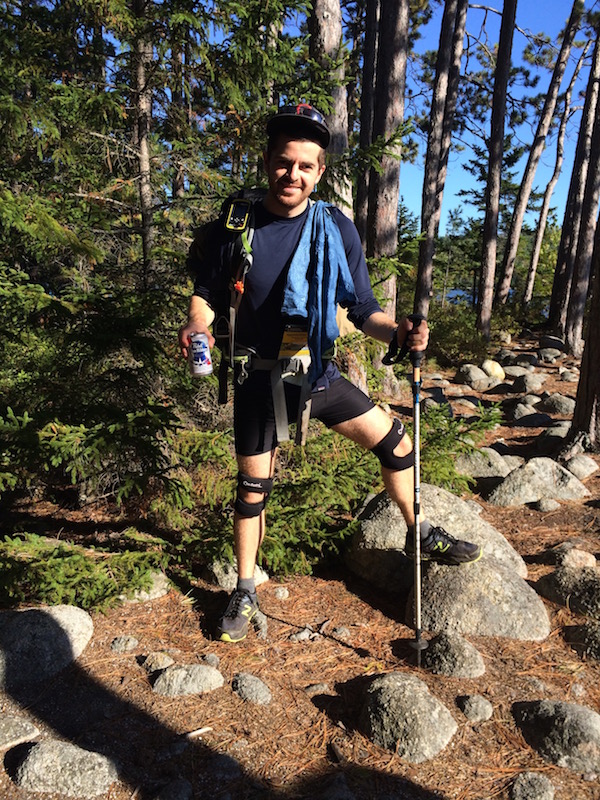
I met up with Nick at 2pm at the Portland train center. We drove to his place and did some final packing and gear review. Our plan was to carry mostly separate stuff – including maps, water purification, toilet paper and bear rope – for redundancy, which would end up coming in handy. The only items we shared were a stove and pot as well as our backpacking dinners.
All in, I had about 12 pounds of gear and 8 pounds of food in my bag when we set out. Packed and ready, we loaded into Nick’s car and drove the 2 hours up to Monson, Maine, getting in just after dusk.
Shaw's Hiker Hostel
When we arrived at Shaw’s, AJ showed us around and offered us a complimentary PBR. 🍺 The hostel ended up being an excellent transition from city life into the dirtbag hiker culture we were about to launch ourselves into. It had the warm glow of friendly travellers as well as the stench of the various aromas they carried with them.
There were many bushy trail beards hanging from the eager faces of Appalachian Trail (AT) thru hikers, almost at the end of their 2000+ mile journey from Georgia.
The hostel offered several showers and laundry machines, as well as a fridge and an assorted book collection in the common room. There was also a bin full of gear that had been abandoned by other hikers that seemed to be free for the taking. A bit like “take a penny, leave a penny” but with platypus bladders and torn off sections of thermarests.

[Click to view full size image.]
Shaw’s also had a pretty extensive gear shed out back, where you could resupply with basically anything you’d need, from backpacks to hammocks to stove fuel to all sorts of calorically dense meals and snacks. As I scanned through their offerings, I saw a number of items I was already planning on carrying, which was reassuring.
For sleeping accommodations, there was an option to stay in a large, shared bunk room, or pitch a tent on their lawn outside. Instead, Nick and I had booked a private double bedroom upstairs.
Exploring Monson, Maine
Once we had found our spot, we headed two minutes into downtown and I grabbed a burger from The Lakeshore House. The diners in the restaurant were a mix of hikers in nano puff jackets and Mainers in worn blue jeans. You really got the sense that the small town of Monson (population 686) relied somewhat on the “tourism” from the AT hikers that passed through.
Their menu was kooky, our waitress was awesome and the burger was delicious.
After dinner we settled in back at Shaw’s. We met Poet and Hippy Chick, the trail names of the two owners of the place, both AT thru hikers in 2008. We reviewed our planned itinerary with them and coordinated our resupply location, time and packages – plus the all-important decision of whether we’d like a cold beer or soda thrown in with our rations when the van met us.
After we went upstairs for the night, I hopped on the wifi for a few minutes, which was necessary since Verizon had no service where we were. I made note of the latest weather reports, which called for rain and thunderstorms on day 2 and 3, when we’d be hitting the mountains. We added an extra dinner to our bags in case we got holed up and needed to wait for storms to blow through.
With that, we were done planning and eager to get started. As Nick said that night: “The plan is the point from which you deviate.”
Day 1: Route 15 to Long Pond Stream
15.1 Miles. On the trail from 8:30am until 5:15pm.
Departing Shaw's
Breakfast the next morning was at 7am. We were served eggs to order along with bacon, hashbrowns and stacks of pancakes. There were a half dozen AT thru hikers that all seemed to know each other at one table, while Nick and I sat with the two other section hikers that were “just” doing the 100 Mile Wilderness.

By 8:15, there were 5 of us ready to hit the trail. We loaded our gear into the covered bed of a pickup truck and headed off into the cool morning mist.
Poet drove and passed along some tips and trail beta. He cautioned us about the slippery slate stones along the first 20 miles of the trail. He also mentioned that many water sources were running low, and that Chairback Gap Shelter (where we planned to stay) had completely run dry.
At the trailhead we unloaded, took a few pictures (for the Shaw’s Facebook page) and then Poet wished us well, and we were off into the woods, eager to put in some early miles.
The First Miles
 The first few hours were still cool and misty. We passed lots of small dammed-up ponds, some where we could walk next to the pond below water level behind some well-engineered beaver dams. There seemed to be lots of signs of beaver activity, although we didn’t see any on the trip, unfortunately.
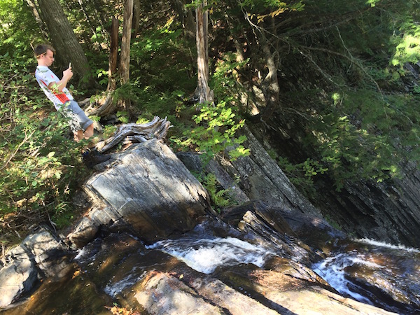
The first notable site we hit was Little Wilson Falls, an impressive slate waterfall that disappeared into a steep, narrow gully. We stopped to fill up on water and have our first lunch of the day. While stopped, we were passed by two Brits – a father and son – who were planning on doing the 100 Mile Wilderness in 5 days. They took off and we figured we wouldn’t seem them again.
Shortly after the falls we began our ascent of Big Wilson Cliffs. This was a nice long section of cliff walking, with our first views of the trip. There seemed to be a pond down below us that wasn’t on my National Geographic map, perhaps more evidence of recent beaver activity changing the landscape.

Down the other side of the cliffs, we reached our first ford at Wilson Stream. Poet had told us this might be the only risky crossing we’d face since things were running low. At about 60’ wide, I decided to switch to my Teva sandals and roll my pants up over my knees. The water proved just deep enough to wash up over my knees, getting my pants a bit wet.
On the far side, we stopped and had our second lunch of the day. I was hoping for an intentionally leisurely pace on day #1 to prevent us from going really hard on excitement and fresh legs, and burning ourselves down too much.
After the stream was a steep ascent up to some railroad tracks and then Wilson Valley Shelter. Then we hit some Pointless Ups and Downs (PUDs), trending mostly downhill. There were sections of trail that seemed to have been freshly cut and didn’t follow the shape on our map. The ground was spongier and softer, since it hadn’t yet seen enough foot traffic to be worn down to bare roots and rocks.
There were a few small stream crossings, all of which were easy to rock hop. Finally we reached Long Pond Stream itself which was also rock-hoppable, despite the “Ford difficult in high water” caution on my map.
Getting Into Camp
On the other side of Long Pond Stream there was a large, flat tent site. We had met up with some AT thru hikers early in the day and they decided to stop here for the night. We pressed on, uphill for a few more minutes to reach Long Pond Stream Shelter.
I remember feeling a bit tingly as we rolled in, ready for dinner and relaxing. From the shelter, I had cell phone service, so I was able to check the weather report: less stormy than anticipated for day 2, but day 3 was still showing thunderstorms. ☔
Since the forecast called for rain overnight, I tried pitching my hammock inside the shelter. After searching the rafters for suitable tie-outs, I picked a pitch that went across the open wall – which ended up being pretty obnoxious since I was blocking most of the entrance to the shelter.
Nick and I shared the shelter with an AT thru hiker that night, while two women camped in a tent nearby.
Day 2: Long Pond Stream to Chairback Gap
10.9 Miles. On the trail from 9:00am until 5:00pm.
The next morning was pretty lazy. I added water to my powdered whole milk and granola which made for a really convenient, filling breakfast (with lots of fat and calories). One of the AT thru hikers who had camped down at the river (trail name “Ranger”) came up and chatted with us and the two women who had spent the night in their tent.
One of the women was obviously a far more experienced hiker, and was helping her friend do the 100 Mile Wilderness as a 50th birthday present to herself. Unfortunately, she had injuried her knee the day before and had decided to bail out after only a day. We helped them find a nearby point for extrication and they called their husbands to come and pick them up.
Pointless Ups and Downs
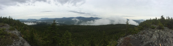
We finally were on the trail at 9am in alternating heavy mist and light drizzle. We immediately hit about 1200 feet of elevation gain up towards Barren Mountain. There were several sections of crude slate staircases that had been setup along the trail by some very rugged, determined trail crews.
After a flat section there was another 600 feet of elevation to the summit of Barren Mountain. At the peak, there was an old lookout tower whose roof had blown off a while ago, leaving splintered wood and debris laying around. There was very poor visibility in the heavy mist, but Nick climbed the old, rusty structure to have a look around.

Next was a relatively flat section of muddy ridge walking amongst short spruce fir trees. We reached the junction for Cloud Pond and stopped to have lunch. At this point, everything was starting to get wet – you couldn’t even find a dry spot to sit without soaking through your pants – which is just a fact of life on longer backpacking trips.
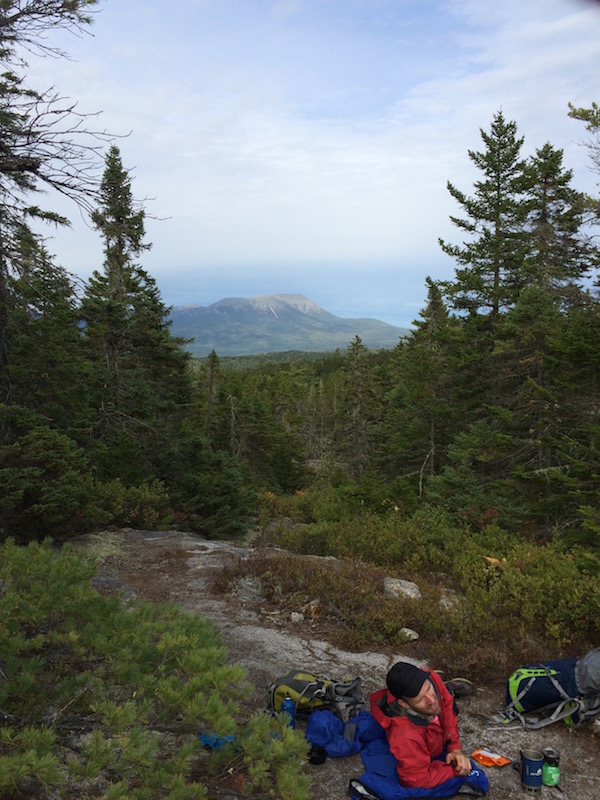
Up next was a string of barely named peaks – Fourth Mountain, Third Mountain and Columbus Mountain. Poet had warned us that many hikers are caught off guard by the rugged elevation changes here. Indeed, the next few hours were lots of long, steep ups and downs. There was no view from Fourth Mountain through the heavy mist, but we got to look back over the Barren-Chairback range to see that day’s progress by the time we got to Third Mountain.

Any time I thought we had reached a place where I might have cell phone service, I checked and found that I did indeed. I was able to check the forecast again a few more times and saw no thunderstorms risk for that day, and a decreased risk for day 3. I kept my fingers crossed.
Before reaching Chairback Gap Shelter, we stopped to fill up at a stream flowing out of West Chairback Pond. We left our packs on the trail and bushwhacked a bit upstream to avoid hiker pollution. I ended up finding a pile of toilet paper swarmed with flies about 10 yards from the stream – always filter your water! – so we pushed a bit further upstream before stopping to fill up.
Worried about running out of water before our next resupply opportunity the next day, I grabbed 4L of water which added almost 9lbs to my pack, making it almost 50% heavier. This extra weight made the final 1.5 miles over Columbus Mountain very strenuous. Again, we got no view for our efforts, but were rewarded with a few sections of freshly moved, soft trail where it had been routed around some obvious erosion problems.
At this point in the trip, I was surprised that my knees weren’t hurting much at all. On my high school swim team, my coach and team mates told me that I had scrawny “chicken legs,” and my knees would usually start to ache after one or two thousand feet of elevation gain. Just today, we had done close to four or five thousand feet, but they felt fine. I was really glad I had picked up two knee braces before the trip.
Making Some New Friends
When we arrived at Chairback Gap Shelter, Nick and I had the whole thing to ourselves. We talked briefly about doing some more mileage for the day since Nick was still feeling fresh.
I stated my initial goal of erring on the side of lower mileage days for the first half of the trip when we’d be going over all of the elevation. I’d feel much better pushing it on the second half of the trip when the terrain was easier and we were closer to the end so there was less at stake.
I setup my hammock inside the shelter again, but parallel with how people lay out their sleeping bags, having learned my lesson from the night before about being in everyone’s way. As the darkness closed in, we figured we’d have the place to ourselves.
As we were settling in for the night, a voice and headlamp descended down the dark trail towards the shelter. Her name was Shotgun, and she told us she had a few friends that were coming behind her. We made room and got to chatting.
She had done a lot of travelling and had some more adventures planned for after her AT thru hike. Eventually, her two companions, Wahoo and Tumbalina also emerged from the darkness under headlamps.
We chatted for an hour or two, without ever seeing each other’s faces – a strange artifact of trail life. We were all just disembodied voices with stories and funny accents projected out from dark faces hidden behind headlamps. It wasn’t until the next morning that I had any sense of what any of them even looked like.
Day 3: Chairback Gap to Logan Brook
17.1 Miles. On the trail from 7:45am until 6:45pm.
Nick and I decided to get an early start so that we’d have a better shot at getting over White Cap Mountain before the thunderstorms that had been forecasted for late afternoon. The original trip itinerary had two options for day #3, one where we went over White Cap and one where we didn’t, making up the mileage the next day instead. We wanted to be in a good position to get ourselves ahead of schedule, so we decided to push for it early.
As we were getting ready in the morning, we discovered a fire still smoldering about 30ft behind the shelter and the familiar dry rectangular patch of dirt indicating someone had tented just behind us, left recently and not bothered to make their presence known. It was a bit spooky. 👻
We hit the trail before our new friends had roused yet and were quickly rewarded to an undercast view from the summit of Chairback Mountain. Down the other side was a large talus field, which was tricky to do with hiking poles since I needed my hands and feet to scramble and hold myself up in a few places.
After the talus was a long, 4 mile descent down to Katahdin Iron Works road, an old logging road that cut through the wilderness around mile 30. We ran into the AT thru hiker named Ranger and asked if he had seen anyone come by that might’ve camped behind our shelter, but he had no idea.
At the road, I stopped to finish my breakfast and Nick pushed ahead half a mile to the Pleasant River crossing to load up on water. I met up with him shortly, and changed into my Tevas to ford the river. Nick managed to rock hop it without falling in.
On the other side, we both did a bit of rinsing off with my Dr. Bronner’s soap and a bandana. I was worried about things not drying so I didn’t wash any of my clothes, just gave myself a good scrub.
Getting into a Rhythm
Up next was a long, slow 5 miles uphill with about 1200 feet of elevation gain, through Gulf Hagas to the Carl A Newhall Shelter. We decided not to take the 5.2 mile Gulf Hagas cutoff trail to “see the sights” as many guidebooks recommended. Supposedly, there are lots of cool waterfalls buried back there in the “Grand Canyon of Maine.”
Nick had hiked through here as a child and was hoping to recreate an old photo he had taken, but the day was misty and cloudy and he figured it wouldn’t come out well.
During the 5 long, uphill miles, Nick and I started getting accustomed to splitting up on the trail. We had different paces over the elevation, and we both found it nice to have some solitude and experience the true wilderness to ourselves. At this point the trail was pleasant enough that we could finally start to make good time, about 2mph, which was some of the fastest stretches of miles on the trip so far.
We took a long break at Carl A Newhall shelter for a late lunch and recharge. We still had 7 miles and ~2500 feet of elevation gain left for the day. My feet were starting to feel really raw and torn up, which was most noticeable when I’d stop hiking. After a few minutes of marching down the trail, they’d go numb again and the pain would abate.
There were a few more summits on the way to White Cap Mountain – the highest point on the trip. We had some hard marching up and over West Peak and Hay Mountain, both with no view for our efforts. Nick and I would stop and meetup on top of the peaks to checkin and then head off again at our own paces.
After three days of hiking in wet clothes, I was starting to get some chafing on the inside of my thighs. It quickly grew from a minor annoyance to fairly painful in about 30 minutes of hiking and I was worried it would only get worse. I tried opening the fly of my pants to vent and dry things out but not much helped.
All Downhill From Here
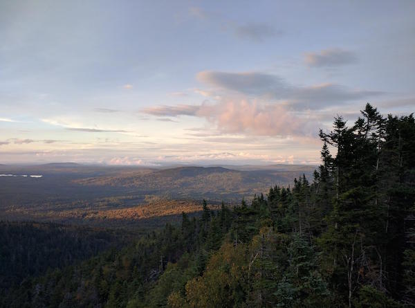
We finally reached the summit of White Cap Mountain around 5:30pm – the final 1.1 miles took nearly 45 minutes. From the peak, we enjoyed a few brief moments of views before the clouds closed in and shrouded everything in a blanket of white mist.
I was very glad we were able to catch some views before that happened – it would have been very frustrating to get no views at all on 3 of the steepest peaks of the trip!
Since we were now starting to get ahead of schedule, we placed a call to Shaw’s to move our resupply from 2:30pm up to 12:30pm for the next day. We had quite a bit of difficulty getting the call to go through, despite everyone telling us we’d have plenty of service up there. Maybe it was the heavy cloud cover running interference.
After White Cap was our final push of the day, down the other side to Logan Brook Shelter. Along the way down, we caught our first views of Katahdin peeking out above the clouds some 30 miles north as the crow flies. It was a spectacular view set against the pink clouds at sunset.
We went down and down over a seemingly endless set of slate stone stairs before finally descending into a grove of paper birch trees just before the shelter. Shotgun was already in the shelter when we arrived, Tumablina and Wahoo arrived under headlamp later in the evening.
I setup my hammock outside the shelter for the first time on the trip so far. I also took off most of my wet clothes to try and dry them out, hoping to ease the chafing that had been developing.
Day 4: Logan Brook to Antlers
19.6 Miles. On the trail from 8:30am until 6:45pm.
Another Wet Morning
On day #4, we woke up to scattered bursts of rain. I bristled at the idea of putting wet clothes back on, and thought about hiking without pants.
I asked the other AT hikers about my chafing problems since I figured it was an issue they’d likely tackled sometime in the last 2,000 miles. Wahoo lent me some Gold Pond powder and squeezed out a bit of diaper rash cream he had been carrying, which instantly cooled my skin and made things feel much better. He also recommended I hike without pants, and said they all had done it during the heat down south.
I also discovered that I had left my toilet paper roll at Chairback Gap shelter’s privy the night before. The AT hikers joked that I had left behind some “trail magic” for the next person who wandered into that privy. Fortunately, Nick had enough that we were able to share for the rest of the trip – I was very glad we had planned some redundancy in key items!
The first 3.5 miles of the day were easy, mostly downhill until we hit East Branch Shelter. The terrain reminded me of the Ewok planet of Endor from the Star Wars movie, everything was very tangled and mossy. We ran into Ranger again at one point, he flew by us at his seasoned AT thru hiker pace, quickly disappearing down the trail.
Moments later, Nick and I heard some heavy crashing and splashing off the trail to our left. Around the next turn, we saw Ranger’s pack and poles laying off to the side of the trail. For a moment, I thought he’d been snatched up by a Yeti – but then we saw him down a ways, bushwhacking through the thick undergrowth to see what had made all that noise. He shouted up to us that he could only see the animal’s head since it seemed to be lying down, and he figured it was a moose.
The Resupply
After a brief rest at East Branch (mostly spent swatting away flies), we faced our final big climb for awhile, up and over Little Boardman Mountain. There were some cool vistas on the way up, but no views from the top of the mountain. It was alright though, I’d learned better than getting my hopes up for views at this point in the trip.
The mist and overcast were finally starting to burn off, leaving behind wispy clouds and a bright blue sky. From the summit of Little Boardman, we had 1.4 miles of downhill to Kokadjo B Pond Road for our resupply. At this point, my feet were really starting to ache and blister up.
I had a fleeting thought that I could just ride out of the wilderness in the resupply van to showers and a bed, but I squashed it quickly and kept on hiking.
I emerged from the woods onto the windy dirty road at 12:30 on the dot. A white pickup truck had just rumbled by – the first signs of civilization we had seen in 4 days – but it was not for us. After 15 minutes of waiting, we began to weigh our options since neither of us had cell phone service to call and check on the drop.
We didn’t really have enough rations left to make it out either end of the wilderness from here, so we were pretty reliant on someone showing up with our resupply bags soon.

At 1pm, we heard the faint sounds of a van’s wheels crackling over the dusty road towards us. The silver van said “Shaw’s” on the side and a man named Gary popped out. “Man, you guys are early!” were his first words to us. We quickly realized our message from the summit of White Cap hadn’t been relayed to him from the afternoon before. Fortunately, he was 90 minutes early so we weren’t kept waiting for too long.
We spend a few minutes combing through our food packs and ended up sending a lot of it back with him. The pita bread I brought was a crumbly disaster, I wasn’t a big fan of the peanut butter or dried fruit snacks either. We had also been carrying an extra dinner and breakfast since we were worried about storms holing us up for a day, but at this point we decided to send those back as well.
I spent a few minutes chatting with Gary and enjoying some salmon and cheetos that I had packed as a “resupply meal” – as well as the complimentary PBR Shaw’s sent us. 🍻
Act II
The resupply, combined with the now clear and sunny weather conditions were a huge morale boost. The one-two punch of Wahoo’s Gold Bond, plus hiking without pants had all but fixed the thigh chafing issue I’d been having, which was very exciting.
A quarter mile down the trail was the sandy beach of Crawford Pond. Here, I spent 15 minutes rinsing my feet off, enjoying my treats and sunning myself on a small log bench someone had left.

It felt like I was on a completely different trip than when we had set out into the cold, wet drizzle earlier that morning. I let out a few primal howls that echoed over the lake. 🐺
Excited about beginning the second half of the trip, I stowed a hiking pole and carried the PBR can in one hand for the next 15 miles. The trail conditions had changed from steep, narrow and rocky to wide, open and flat. There was no more elevation in the schedule for the day, just a very gradual descent of 700ft over the next 10 miles. I started cruising closer to 3 or 4 miles per hour and making substantial, satisfying progress.
The miles were so flat and uneventful that they started to get a bit boring, in fact. Nick tried hiking with one earbud in, listening to music, but I just let my mind wander. I had to keep myself distracted to ignore the roaring pain in my feet. I stopped briefly at Jo Mary Road to load up on advil and water.
Antlers
We cruised by our intended goal for the day – Cooper Brook Falls – before 3 o’clock. We had heard that Antlers campsite was one of the best lake-side spots on the entire AT. With the morale boost at the resupply, we figured we could push hard and put in close to a 20 mile day to get there.
Boy was it worth it.
I got to the lake just as the sun was setting, running the last few hundred yards to snap a shot of the pink clouds over the endless, still water. Nick had already snagged a campsite on the tip of the peninsula, right on the water.
At this point in the trip, we had developed an informal system of bird calls we used to communicate where we were, when we were too far to apart to shout clearly. #justhikerthings 🐣 I used that to locate him in the sprawling campsite.

In the fading sunlight, I waded out into the lake to soak my feet as well as rinse myself and wash my clothes for the first time. I was still impressed that my knees were holding out well and that I had no real pain or stiffness aside from the blisters on my feet.
Some nights my neck and shoulders had been a bit stiff from my pack’s suspension, but a good night’s sleep in the hammock made everything better and I woke up feeling fresh every morning.
I strung up my hammock in the dark between two trees right on the water so that I was facing east, for optimal sunrise viewing. In addition to spaghetti with meat sauce for dinner, we also made the mashed potatoes with bacon bits, which I had packed as an extra comfort food for a long day. It felt like we had earned it.
Before we had a chance to hang our food bags for the night, some mice chewed a hole in my hip belt pocket to get at the chocolate chips I had kept in there. Later on, a mouse would crawl right over my bare foot as I was eating dinner. A good reminder that we’re in their home and shouldn’t tempt them to destroy our gear to get at snacks – hang your food! 🐭
Since we were now 7 miles ahead of schedule, we had no real plan for the next day. We figured we’d see how we were feeling in the morning after taking care of blisters and go from there. We hadn’t seen Shotgun, Wahoo or Tumablina yet, but were hoping we’d run into them again the next day.
Day 5: Antlers to Crescent Pond
17.9 Miles. On the trail from 9:00am until 6:00pm.
I woke up naturally around 5:45 to the soft glow of sunlight starting to creep up over the horizon. Over the next hour, I watched the lake and its creatures shake off their slumber and begin a new day. I snapped some great pics from inside my hammock as well as from around our campsite.

Settling Into Life on the Trail
I hung up a clothes line to finally dry things out in the sun’s strong rays. Nick and I also spent some time lancing and draining many of the blisters that had formed on our feet. While it grosses some people out, the process of treating a blister is completely painless and helps relieve a lot of the pressure you feel while hiking.
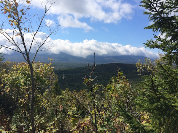
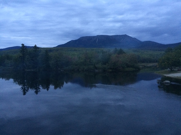
After a long lazy morning tending to our feet, we hit the trail for some flat, easy miles to the shore of Pemadumcook Lake. From here, we got a cool view of Katahdin, which was getting noticeably closer now than it was when we had first seen it on day #3 coming down White Cap Mountain.

After a small rock hop, I spent some time getting water, soaking my feet and eating lunch at a small stream. Even though I had drained a few blisters that morning, my feet were still pretty badly chewed up with blisters forming on the toes, heels and balls of both feet.
I was trying hard not to adjust my stride to ease the pain, since compensation like that can quickly lead to other weird overuse injuries as untrained muscle groups try to pick up the slack. My plan was basically to soak my feet in cold water, drain any large blisters and load up on advil every 3-4 hours for the rest of the trip.
We pushed on another few miles, hiking along Nahmakanta Stream. Even though it was relatively flat, the trail was extremely rocky and rooty, making it hard to get in a good cadence. There were a few PUDs mixed in for good measure, as the trail would wander closer and farther from the stream.

Finally, the stream widened as it reached its origin at the south end of Nahmakanta Lake. The wind was blowing hard over the lake, gusting to 25 or 30mph and creating steady swells that washed up on the shore in front of us. We saw two older gentlemen struggling to paddle a canoe across the lake, and spoke with another older couple who had just decided to nix their planned kayak across the lake for the day.
In the chilly breeze, I decided to try putting my pants back on for the first time since the previous morning, but very soon realized it was a mistake. A bit of climbing up and over ledges had me sweating profusely again, so I ripped them right back off when we stopped at Wadleigh Stream Shelter.
At this point in the trip, there wasn’t really a concept of morning, lunch time or afternoon. Once you hit the trail in the morning, you kinda took things in chunks of 3-5 miles, stopping to eat and take care of problems as they arose. The idea of appropriate times for breakfast or lunch breaks gave way to taking bites of salami and cheese (or scoops of nutella) whenever you were hungry. I made sure to have some sugary energy chews and chocolate chips in my hipbelt pockets for easy retrieval on the trail as energy waned during mid-afternoon.
Some Frustrated Miles
After the long previous day, I was hoping for a shorter day ending at Wadleigh Stream Shelter, but when we reached it, there was still plenty of daylight left. Nick seemed eager to put in more miles – excited at the prospect of doing some night hiking by headlamp – so I begrudgingly agreed to soldier on.
Fired up from my frustration over more miles – and wanting to get it over with – I flew up the steep 600 foot scramble over Nesuntabunt Mountain. I paused briefly at the top to take in Katahdin and the view of the windy lake now far below, and then took off down the other side. I spent a minute chatting with another hiker at the summit, trail name of “Ziplock” who I’d run into again.

Shortly after crossing a dirt access road, Crescent Pond emerged through the woods. I had read in the AMC’s guidebook that this was a favorite spot for locals, even though it wasn’t marked as a campsite on any of our maps. I followed the trail as it circled the shores until I came to a suitable spot with good water access and dropped my pack as the sun was disappearing behind the trees.
I chugged some water and soaked my feet, looking forward to dinner and a good night’s rest.
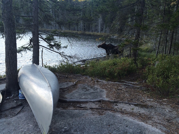
A few minutes after Nick showed up, a moose emerged from the woods for a drink and a snack next to us on the shore. She sized us up and edged closer a few times – only a few paces away at one point – before scampering back up and over a ridge.
Several minutes later Ziplock showed up again, pitching his hammock nearby.
Nick and I discussed the plan for tomorrow. We had 18 miles left and could potentially finish a whole day early. I told him my feet weren’t in great shape but I’d see how I was feeling the next day. As I looked at the map in my hammock later that night, I realized there was no way that I’d want to stop with only a few miles left, so we’d likely be pulling another long day and finishing early.
I was excited at the idea of finishing early… but my feet weren’t so much. 👣 😵
As we were hanging the bear bag, Wahoo came through camp, hiking by headlamp. He told us that they hadn’t ended up making it to Antlers the night before, but were trying to make up lost time to reach Katahdin in 2 days and complete their AT thru hike. We exchanged contact info and wished him well.
I climbed into my hammock and settled in for a restful night’s sleep. I would need it! Laying on my back and looking up through the branches, I saw an incredible canopy of stars, something a city boy doesn’t see too often. A few shooting stars flew by as I nodded off quickly.
Around 2:15am, I woke up to the sound of Shotgun and Tumbalina chatting merrily as they came through camp. They hadn’t seen my hammock setup a ways off trail so they kept right on hiking. I was too groggy and confused to say hello before they had rounded a bend and disappeared from ear shot. I went back to bed wondering if I’d see them again.
Day 6: Crescent Pond to Abol Bridge
18.8 Miles. On the trail from 9:00am until 6:45pm.
I slept in till 8am, the latest wake up time on the whole trip. Ziplock had already woken up, broken camp and hit the trail by the time I was up.
It had gotten very cold overnight under the clear skies as all of the previous day’s heat escaped up into the sky. My hammock and bottom insulation had been keeping me warm without much need for the sleeping bag up to this point on the trip, but I woke up several times shivering overnight and ended up donning my puffy jacket and a hat, curling up into a ball under my sleeping bag as the temperature plummeted.
On Track to Finish Early
We reached Rainbow Stream Shelter at 11am, at the southern tip of the final lake of the journey. Along the way, we ran into Wahoo hanging out of his tent making breakfast. He had hiked for another hour or so after seeing us the night before and then lost the trail near a bridge in the dark. He decided to camp out and wait until morning to continue.
It was another 2 hours into Rainbow Spring Campsite on the southern shore of Rainbow Lake. By this point, we had caught up to Ziplock. We stopped and chatted with him at lunch for a while, swapping snacks and gear tips. We also chatted with a Southbound, flip-flopping thru hiker named Cautious. Since I knew we were on track to make it out, I scarfed down extra portions of meat, cheese and gatorade so I wouldn’t have to carry the extra weight on my back.
From Rainbow Spring Campsite, the next few hours were chatting with Nick and Ziplock about a ton of stuff. Ziplock was doing the 100 Mile Wilderness over 9 days and had planned to spend the night at Rainbow Spring Campsite, but he decided to join up with us and hike out a day early. We talked a lot about fitness and health and technology, and the final miles really flew by.

The Final Push
After several hours and a few hundred feet of climbing, we stopped atop Rainbow Ledges. Here, we ran into the Brits who had passed us in the morning on day #1! They were reclining on the rocks, enjoying a picture-perfect view of Katahdin framed between some pine trees. They had gone hard during the early, rainy elevation in the first half of the trip, but decided to ease off and enjoy the experience the past few days.
They were planning to get a shuttle back to Shaw’s the next day, and Ziplock was as well. We all took the opportunity with some cell phone service to make a few calls and figure out logistics for getting home from here since we were all changing up our scheduled itineraries a bit.
Our plan was to get a ride back down to Monson with Nick’s friend Dave, who was camping at Katahdin Stream Campsite, a few miles past the end of the 100 Mile Wilderness. We had shot him a note a few days earlier that we might potentially get in earlier than scheduled, but he was unreachable now that he was in the cell phone coverage wasteland of Baxter State Park.
Since we weren’t able to get a hold of him, I wasn’t totally sure what the plan was when we finished, but Nick seemed confident we’d figure it out.
The final 6 miles were mostly downhill. It started to get dark towards the end as the sun was setting and the forest canopy was getting thicker over our heads. Finally, we emerged from the woods on Golden Road just after sunset, another long day! The first sight we were greeted with was two logging trucks lumbering by in each direction.
Back in Civilization, But Not Out of the Woods Yet
It took a minute to figure out where to go from the road, but eventually we made a right and did some road walking until we came to thee Abol Bridge over the west branch of the Penobscot River. Katahdin towered over us in the background as we crossed the wide, swift river.
We made it into the Abol Bridge Campground general store just before they closed at 7pm and I quickly put back a gatorade and started nursing a beer with Ziplock. Excited to be finished, we took a seat on a large flat rock outside the store and enjoyed our beverages.
Nick hurriedly told me his plan was to run the 4 miles of trails between us and the Katahdin Stream campsite where his friend was staying. I would stay outside the store with both of our bags, and he would come back with Dave to pick us up and drive us both up to Dave’s campsite for the night.
I didn’t think much about the plan but since it entailed me basically just sitting down for awhile, I nodded as he took off into the descending darkness. He had wanted to do some night hiking and this was his chance, I thought.
Ziplock and I sat on a flat rock outside the store for a while, sipping our beers and chatting as giant logging trucks lumbered by, kicking up a dusty wake on the dirt road.
After about an hour, Ziplock bid me good night. He had rented a cabin from the store owners out back and was looking forward to showering off and sleeping in a bed.
As he wandered off, I sat there alone in the dark for a while, conserving my headlamp battery and starting to mull over the “plan” that was already in motion.
Nick had been gone for about 90 minutes now and I wasn’t entirely sure what I would do if he didn’t show up with Dave in the car shortly. What if he can’t find Dave at the campsite? What if he gets lost or doesn’t reach the campsite for some reason? How long should I wait before I start to get worried?
When he ran off, he had left all of his gear with me, besides his headlamp. He was wearing a t-shirt and shorts and the forecast called for rain and 40° temps overnight.
I took the last swig of beer and sat back on the rock, trying to think of what my options were for finding him from the edge of a dirt road, next to a tiny, closed outpost, with no cell phone service.
Before I had much time to mull it over, some bobbing shadows caught my eye and suddenly Nick appeared right next to me, seemingly out of thin air. “That… was a terrible idea” he panted breathlessly, doubled over and covered in sweat.
The trails signs had been very unclear and he had been jogging around the mountain in his hiking boots for almost 2 hours with no idea if he was going the right away. Eventually he decided to turn around and miraculously found his way back without getting lost in the dark.
Relieved to see him alive and in one piece, I told him we could probably bum a cot in Ziplock’s cabin. We carried our bags back to the cabin and I made us dinner as Nick caught his breath and we settled in for the night.
Day 7: Getting Home
The next morning, Nick attempted his plan for reaching Dave again, but a bit more methodically this time. He would walk the 4 miles up to Dave’s campsite, bringing a map, snacks and rain jacket. We set a schedule and a cutoff time and agreed what we’d do if we hadn’t seen each other within a few hours. I’d stay with the bags and wait to see if Dave showed up at Abol Bridge, in case he came looking for us and they missed each other.
It turns out that that’s exactly what happened, Dave found me about an hour after Nick left, sitting just outside the store under an awning, trying to stay dry in the light drizzle. I said my good byes to Ziplock, Ranger and a few other hikers that had shown up at the store for breakfast.
We loaded up the bags and drove back up to the campsite, where we found Nick wandering down the side of a dirt road. He had made the hike up and hitched a ride into the campsite for the last stretch, before finding Dave’s tent site vacant and wandering back out of the campgrounds.
Finally all together and in the car, we made the drive back down to Monson to fetch Nick’s car and settle up with Shaw’s for the lodging, resupply, breakfast and parking.
It took about 2 hours of driving to cover what had taken us 6 days to hike. We passed by familiar dirt roads that had cut through the wilderness and got to see signs for the camps and huts that had dotted the lakes we trekked by.
It was an amazing feeling of accomplishment, and a humbling realization of just how big the wilderness can be.